National Geographic Atlas of the World
Rare book

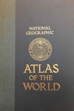
National Geographic Atlas of the World

The fifth edition of the National Geographic Atlas of the World from 1981 is a monumental cartographic work. It contains detailed maps, satellite imagery, and geographic data from the height of the Cold War.

The fifth edition of the famous cartographic atlas National Geographic Atlas of the World, published in 1981, represents one of the most comprehensive and high-quality editions of the National Geographic Society from the second half of the 20th century. Recognizable by its large format and distinctive yellow accents, this atlas combines superb cartographic precision, rich thematic units and high aesthetic value for which this publisher is world-renowned.

The content includes extremely detailed physical and political maps of all continents, oceans, polar regions, as well as space and the Solar System. The 1981 edition offers a fascinating historical insight into the geopolitical picture of the world at the height of the Cold War – with clearly delineated borders of the USSR, Yugoslavia, Czechoslovakia and political divisions in Asia and Africa before the collapse of the bloc system.

In addition to classic maps, the atlas contains a rich text section, statistical data on the population and economy, climate diagrams and the most modern satellite images of the Earth at the time. This edition is highly regarded among antiquarian book collectors, geographers, and cartography enthusiasts, and serves as an excellent visual and historical document of a time.

Dimensions
48 x 32 cm
Pages
385
Publisher
National Geographic Society, Washington, 1981.
 
Latin alphabet. Hardcover.
Language: English.

One copy is available

Condition:Used, excellent condition
 

Are you interested in another book? You can search the offer using our search engine or browse books by category.

You may also be interested in these titles

Geografski atlas Europe

Geografski atlas Europe

Denis Šehić, Demir Šehić

The atlas provides a systematic overview of Europe through physical and political maps, thematic maps, statistical data and country profiles, enabling an understanding of the continent's natural and social features. The secod book in the "Collection of At

Profil Knjiga, 2009.
Croatian. Latin alphabet. Hardcover.
5.24
Velika enciklopedija zemalja 9: Istok i jugoistok Azije

Velika enciklopedija zemalja 9: Istok i jugoistok Azije

24 sata, 2009.
Croatian. Latin alphabet. Hardcover.
5.94 - 5.98
Geografski atlas Hrvatske

Geografski atlas Hrvatske

Denis Šehić, Demir Šehić

The atlas provides a detailed overview of the natural, social and economic characteristics of Croatia through contemporary maps, thematic overviews, statistical data and an overview of all Croatian regions. The first book in the series "Collection of atla

Profil Knjiga, 2009.
Croatian. Latin alphabet. Hardcover.
5.72
Atlas svijeta – Novi pogled na Zemlju

Atlas svijeta – Novi pogled na Zemlju

The atlas literature in our language "Atlas of the World - A New View of the Earth" is the first modernly conceived atlas.

Sveučilišna naklada Liber (SNL), 1978.
Croatian. Latin alphabet. Hardcover with dust jacket.
6.82
Grosser Autoatlas Europa: 1:800000

Grosser Autoatlas Europa: 1:800000

Freytag & Berndt, 2011.
Croatian. Latin alphabet. Hardcover.
9.74
The New International Atlas

The New International Atlas

The monumental cartographic work The New International Atlas by Rand McNally from 1980 provides extremely precise multilingual maps and a detailed overview of the geopolitical landscape of the world during the Cold War.

Rand McNally, 1980.
English. Latin alphabet. Hardcover with dust jacket.
28.46